Columbus and the stars
In 1492 Columbus did not sail by the stars but by dead reckoning: course, speed and time. He used the stars little, and when he measured them, it went wrong. Nor did he think the Earth was flat; he thought it was smaller than it is.
Dead reckoning
- The journal of the first voyage records the course and the distance run every day, in miles and leagues. [1]
- On September 9, 1492, he made 120 miles in the night, “at the rate of 12 miles an hour, which are 30 leagues.” [1]
- That night the sailors steered badly, “letting the ship fall off to N.E.,” and Columbus complained about it many times. [1]
- Time was kept with half-hour sand glasses. On December 13 Columbus counted “twenty half-hour glasses” for the day, and he added that there might be an error, because the glasses may not have been turned with equal quickness or some sand may not have passed. [1]
- Near the coast they took soundings. On November 16 he found a sandy bottom at 15 or 16 fathoms everywhere, “a thing much desired by sailors, for the rocks cut their anchor cables.” [1]
- That the compass needle did not point exactly north on this voyage, and how Columbus explained it, is on the page about the golden compass of Hoorn. [1]
Two reckonings
- On September 9 Columbus decided to report fewer miles than had been sailed, so that the crew would not be frightened if the voyage was long. [1]
- On September 10 he made 60 leagues, but counted only 48 for the crew. [1]
- On September 25 the journal says: “Thus two reckonings were kept on this voyage, the shorter being feigned, and the longer being the true one.” [1]
Measuring the Pole Star
- On November 2, 1492, on the coast of Cuba, Columbus took an altitude with a quadrant and found that he was 42 degrees from the equator. [1]
- Markham notes that this would be a copying error: “It should be 22.” [1]
- On December 13, on the coast of Hispaniola, he found 34 degrees. [1]
- On February 3, 1493, he could not take the altitude, “either with the astrolabe or with the quadrant, because the rolling caused by the waves prevented it.” [1]
- According to Pickering, Columbus measured the Pole Star. He counts at least five attempts on the first voyage to find the latitude from the stars; none of them succeeded. [4]
- Kelley (1983) suggested that Columbus read the tangent scale on his quadrant instead of the degrees. That is an explanation after the fact, not an established finding. [4]
- Our own calculation: in 1492 the Pole Star stood 3.46° from the celestial pole (today 0.63°), computed back from its present position with its proper motion and precession. So it circled the pole every night, and its altitude was at most 3.5° above or below the observer’s latitude.
- Our own calculation: the north coast of Cuba lies at about 21° to 23° north, the north coast of Hispaniola at about 19° to 20°. Off Cuba the Pole Star thus stood between about 18° and 26° high, off Hispaniola between 16° and 23°. Columbus’s 42 and 34 degrees are 15 to 20 degrees too high.
An Earth too small
- Columbus’s favorite book was the Imago Mundi of Cardinal Pierre d’Ailly. His own copy, with notes in his hand, is in the cathedral of Seville. [2]
- According to his son Hernando, one of his arguments for a short voyage west was the opinion of “Alfragranus” (the astronomer al-Farghānī), who allowed only 56⅔ miles to a degree. [3]
- Hernando also writes that his father found for himself, on voyages between Lisbon and Guinea, that a degree on Earth is 56⅔ miles. [3]
- In his letter on the third voyage (1498) Columbus still reckons with “fifty-six miles and two-thirds to a degree.” [2]
- According to IEEE Spectrum, al-Farghānī meant the Arabic mile of 7,091 feet, while Columbus assumed the Roman mile of 4,856 feet. [5]
- Our own calculation: 56⅔ miles times 360 degrees is 20,400 miles. In Roman miles of 4,856 feet (1.48 km) that is about 30,200 km, in Arabic miles of 7,091 feet (2.16 km) about 44,100 km. The real circumference at the equator is 40,075 km.
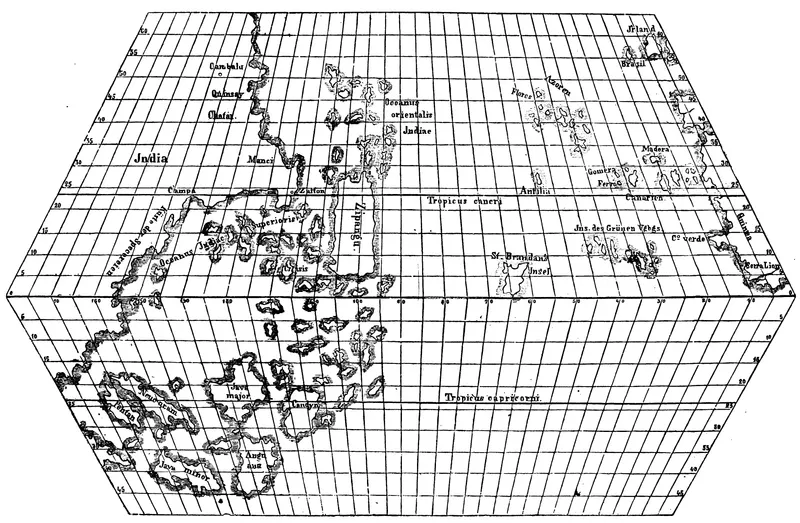
- In 1474 Columbus received an answer from the Florentine scholar Paolo Toscanelli, with a copy of a letter to Martins and a chart on which the coasts of Asia lay “at a moderate distance” from Europe and Africa. [2]
The pear of 1498
- Columbus himself wrote: “I have always read, that the world comprising the land and the water was spherical.” [2]
- On his third voyage he came to another conclusion: the Earth is “not round as they describe, but of the form of a pear,” with in one place a protrusion “like a woman’s nipple,” the highest point and the nearest to the sky, under the equator. [2]
- There, he thought, lay the Earthly Paradise, “whither no one can go but by God’s permission.” [2]
- As his reasons he gave what he had seen himself: beyond a hundred leagues west of the Azores the weather changed, and he had never seen so much fresh water right next to seawater. [2]
- He wrote this in 1498, six years after reaching America. For the first voyage he reckoned with a round but too small Earth. [2], [3]
What is wrong: the flat Earth
- In 1492 no educated person doubted that the Earth is a sphere. According to Russell, at most two to five early Church Fathers denied it. [6]
- Hernando Colón wrote the biography of his own father. [3]
- According to Hernando, the commission the sovereigns consulted thought the world too large: it was doubtful whether one could reach the eastern end of India “in three years.” [3]
- Another objection was that whoever sailed too far west “would then go downwards upon the rotundity of the globe, and then it would be impossible to sail up again on their return, which would necessarily be to climb up hill.” [3]
- That objection assumes a round Earth.
- According to Russell, the picture of scholars at Salamanca contradicting Columbus because the Earth was flat comes from Washington Irving (1828); the French scholar Letronne (1834) attributed a flat Earth to the Church Fathers. [6]
- From the 1860s, according to Russell, the story entered schoolbooks, among others through John Draper and Andrew Dickson White. [6]
What is wrong: the egg of Columbus
- The story is in Girolamo Benzoni, in 1565, more than sixty years after Columbus’s last voyage. He tells what he “ho inteso”: what he has heard. [7]
- At a banquet a Spanish nobleman says that someone else would have found the Indies too. Columbus has an egg put on the table and challenges the others to make it stand, not with bran, salt or oats under it, but “nudo senza cosa alcuna”: with nothing at all. [7]
- When no one succeeds, Columbus sets the egg down on the table with a tap. The tip is slightly crushed, and the egg stays upright. The moral: “dopo il fatto ciascuno sà fare,” after the deed everyone knows how to do it. [7]
- Benzoni himself adds that it had been done before in another way: “ancora che sia stato fatto anticamente in altra maniera.” [7]
- Fifteen years earlier, in 1550, Giorgio Vasari tells almost the same story of the architect Filippo Brunelleschi and the dome of Florence, with “si dice”: it is said. [8]
- So the egg is about ingenuity, not about the shape of the Earth. [7], [8]
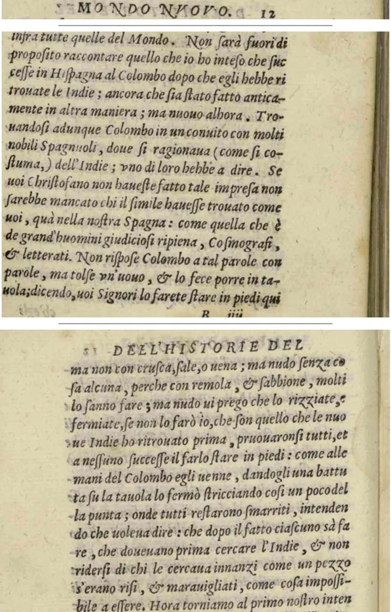
Trouandosi adunque Colombo in un conuito con molti nobili Spagnuoli, doue si ragionaua (come si costuma,) dell’Indie […] Non rispose Colombo a tal parole con parole, ma tolse vn’uouo, & lo fece porre in tauola […]
[fol. 12v] […] dandogli una battuta su la tauola lo fermò stricciando così un poco della punta; onde tutti restarono smarriti, intendendo che uoleua dire: che dopo il fatto ciascuno sà fare […]
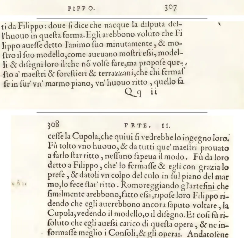
doue si dice che nacque la disputa dell’huouo in questa forma […] che chi fermasse in sur’ vn’ marmo piano, vn’ huouo ritto, quello facesse la Cupola […]
[p. 308] Fù da loro detto a Filippo, che’ lo fermasse & egli con grazia lo prese, & datoli vn colpo del culo in sul piano del marmo, lo fece star’ ritto.
What we do not know
- Exactly where Columbus was when he measured on November 2 and December 13; that is why we reckon with the latitude of the coasts.
- Which reading of November 2 is right: the surviving text has 42 degrees, Markham takes it to be a copying error for 22.
- Whether the “true” distances in the journal were right: they too are Columbus’s own; there is no outside check.
- We know the journal only from the abstract made by Bartolomé de las Casas; we did not read the Spanish text.
- Benzoni does not say from whom he heard the story of the egg.
- We have not read the books by Morison (1942), Phillips (1992) and Flint (1992), nor the article by Kelley (1983).
Sources
- Journal of the First Voyage of Columbus (the abstract made by Bartolomé de las Casas), in: Journal of Christopher Columbus (during his first voyage, 1492–93), translated and edited by Clements R. Markham (London: Hakluyt Society, 1893), PDF from the University of Kentucky We read pp. 22 to 31, 66 and 67, 78 and 79, 110 and 111, and 170 and 171, with the notes by Markham, Navarrete and Herrera.
- R. H. Major (trans. and ed.), Select Letters of Christopher Columbus (London: Hakluyt Society, 1870), Project Gutenberg We read Major’s introduction (on the Imago Mundi and Toscanelli) and the narrative of the third voyage (1498).
- Hernando Colón, the biography of his father (Italian 1571), in the English translation from Churchill (1704), revised by Robert Kerr, A General History and Collection of Voyages and Travels, vol. 3 (1824), Project Gutenberg We read chapter I, sections I to III. We did not read the Italian original.
- Keith A. Pickering, Columbus and Celestial Navigation, The Columbus Navigation Homepage From Pickering we took the attempts to find the latitude and Kelley’s explanation. We did not read Kelley’s article itself.
- Columbus’s Geographical Miscalculations, IEEE Spectrum, October 9, 2012 On al-Farghānī and the Arabic and Roman miles.
- Jeffrey Burton Russell, The Myth of the Flat Earth, lecture for the American Scientific Affiliation, Westmont College, August 4, 1997 We read the whole lecture, but not his book Inventing the Flat Earth (1991).
- Girolamo Benzoni, La historia del Mondo Nuovo (Venice: Francesco Rampazetto, 1565), Biblioteca Nacional de España, R/293 We read fols. 12r and 12v in the scan of this copy.
- Giorgio Vasari, Le vite de’ più eccellenti architetti, pittori, et scultori italiani (Florence: Lorenzo Torrentino, 1550), vols. 1 and 2, Getty Research Institute, Internet Archive We read Parte II, pp. 307 and 308, in the life of Filippo Brunelleschi.
Each statement above carries the number of its source; our own calculations are marked as such. Read on November 16, 2026. What we could not confirm in a source we read is left out or listed under what we do not know.