Cellarius’s Hoorn
The Golden Compass of Hoorn
Reynier Pietersz. van Twisch and his azimuth quadrant, 1595 to 1611
In 1597 a pilot from Hoorn (a ship’s navigator, who worked out the course and the ship’s position from measurements of the sun and stars), Reynier Pietersz. van Twisch, was granted a patent for an instrument that was to show, by measuring the sun, how far a compass needle points away from true north [5][6]. Simon Stevin pictured it in 1599 [2].
This page explains how the instrument worked, lets you try the method yourself, and says where the sources disagree. Where we could not check a statement in the source itself, we say so.
What it was
The instrument is a quadrant of a circle that stands upright on a horizontal circle divided into 360 degrees, with a magnetic needle in a glass-covered box. A sloping rule, the sight, turns about one corner of the quadrant. The whole is made ‘hanging on two axes, in the manner of ship’s compasses’, with a weight of 25 or 30 pounds underneath, so that the circle stays level when the ship moves [2][3]. The Latin text of 1599 calls it a quadrans azimuthalis, an azimuth quadrant, and says it was made after the invention of ‘Reginaldus Petraeus’, whom we read as Reynier Pietersz. [1][4].
Our line drawing below follows the drawing on page 19 of the Latin edition. We do not show the scan itself: the library allows only non-commercial use [1]. Beside it is a small woodcut from a book printed forty-four years later, showing the same type of instrument.
Letters in the drawing
- A B C
- The three corners of the quadrant of a circle. The text says it stands at right angles on the horizontal circle.
- B D C E
- The horizontal circle, divided into 360 degrees. It marks the horizontal plane. In the drawing D is at the front and E at the back.
- F
- The centre of that circle. The quadrant can turn about it.
- G
- Named in the text only for the support that runs from G to D and E, fixed to the quadrant so that it turns with it. The drawing does not show that support clearly.
- H
- The weight of 25 or 30 pounds that is fastened beneath, so that the circle stays level more surely. It is drawn as a dotted outline.
Without letters in the drawing: the degrees on the arc of the quadrant (0 to 90); the sloping rule that turns about B (our reading: what the text calls the alidade, which can be turned higher or lower); and the dark pointer (our reading: the magnetic needle, which according to the text lies in a glass inside the circle). The text also says that the whole instrument hangs on two axes in the manner of ship’s compasses (the Dutch text; the Latin says ‘ad instar Haloscopii’); the drawing does not show the axes. The drum under the circle is drawn but not explained in the text we read. ‘Reginaldus Petraeus’ is, in our reading, Reynier Pietersz.
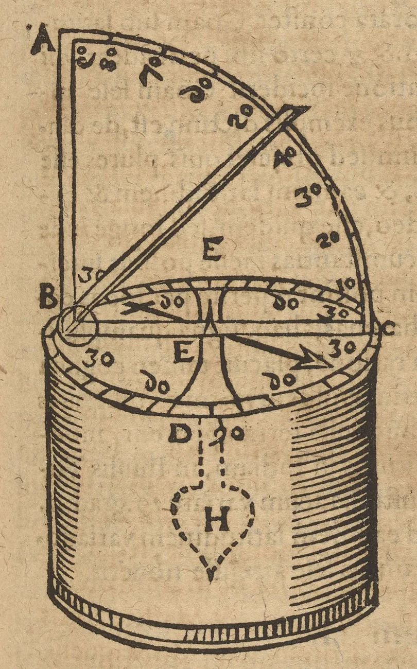
The woodcut is not a drawing by Van Twisch but a later picture of the same type of instrument. Kircher writes that he happened to see one of that kind in Rome and that it was ‘nothing other than a hanging azimuth quadrant’. He does not name Van Twisch or Stevin, and we do not know whether his woodcut was made from Stevin’s drawing. The letters A, B, C and the weight H are in both pictures, which we note as an observation, not as proof [11].
How it worked, in 1599
Stevin’s method needs no clock. Before noon you turn the circle so that the needle points to the start of the scale, turn the quadrant until sunlight falls through the sight, and write down the position on the horizontal circle and the height of the sun, say 40° and 25°. After noon you wait until the sun, now descending, stands at the same height of 25°, and turn the instrument again. The middle of the arc between the two positions is the north point; as far as the needle lies from it, so great is the declination of the compass (Stevin’s Greek word is chalyboclisis) [1]. In the Dutch text he puts it so: ‘t’middelste punt des boochs int sichteindersplat tusschen deerste en tweede ervaring, is tgesochte noortpunt’, the middle point of the arc between the first and the second observation is the north point sought [2].
Why equal heights? At equal heights the sun stands as far east of true south before noon as it stands west of it after noon, so the middle of the two positions is the true meridian. That reasoning is ours; Stevin states the rule, not the proof.
You can take two, three, four or more pairs, for example with the sun at 10°, 15° and 20°, and the same heights again after noon. At night the same can be done with a fixed star, but not with the Moon, which moves too fast and has too large a parallax. On a ship that sails from east to west, or west to east, the deviation can change by a degree or more within ten or twelve hours between the first and the last observation (the Dutch text) [2]; then, the Latin adds, the skipper must judge [1].
Try the method yourself
Everything here happens in your browser. Nothing you enter is sent or stored.
A. The method of 1599
Watch the instrument at work
Our own simplified drawing of the instrument, seen from the south and from above. It follows the numbers you enter below: when you change them, the quadrant turns first to angle a (morning), then to angle b (afternoon), and then true north is marked and the declination coloured in, with the result underneath. The start values are Stevin’s first example.
Step 3, the middle: halfway between the two positions lies true south (opposite it, true north). The arc between it and the needle is the declination, D = (a − b) / 2 = 10°00′, east.
Declination: 10°00′, east. The middle of the two positions is true south; the needle lies this far from it.
The method assumes the northern hemisphere and a sun in the south at noon. On a ship that sails east or west, the sun’s position changes between the two readings.
B. A simulated sun
Pick a day, a place, a height of the sun and a made-up declination. The page shows the angles a and b that the instrument would give, and works the declination back out with part A.
C. Today, not 1599
The World Magnetic Model WMM2025 gives the declination for the place in part B on the date of today [13]. It is a modern model and says nothing about 1599.
Local deviation (buildings, iron in a ship) is not in the model. The coefficient file says the model runs from 2025.0 to 2030.0, while NCEI also gives 31 December 2029 as its end date; we do not calculate after 2029.
Plancius’ theory and why it failed
The compass needle does not point to true north, and where it points differs from place to place. The geographer Petrus Plancius thought this deviation followed a fixed pattern: four meridians along which it is zero (one over Flores and Corvo in the Azores, others at 60° near Cape Agulhas, at 160° near Canton and at 260° in western California), with a regularly growing and shrinking deviation in between. De Jonge attributes a manuscript with these ideas, very probably, to Plancius [6]. With such a pattern a navigator who measured the deviation and knew his latitude could read his longitude from a small brass plate with curved meridians on an astrolabe [10].
That is why this instrument mattered: it measured exactly the number the theory needed. According to De Jonge the Havenvinding itself is a report that Stevin wrote on the orders of Prince Maurits about the ideas of Reynier Pietersz. and Plancius on finding longitude from the deviation [6]. Stevin himself reports that Prince Maurits, as admiral, gave the Admiralty orders and instruction so that pilots on such voyages would carefully measure the deviation of the needle at many places, report it on their return, and have it made public for everyone [2].
The theory failed. Fewer than a hundred measurements existed, and none in the region between the meridians over China and Mexico [10]. Stevin wrote that, on wider experience, the deviations ‘do not obey any axis point’ [2], and proposed six meridians as a hypothesis [10]. And the deviation at one place changes over the years: in 1611 captain Jan Cornelisz. May tried the method and called it ‘imperfect and complete folly’, and in 1635 Gellibrand showed the change over time, which undid every fixed model [10]. The gathering of data itself went badly: Albert Hayen writes in his booklet that the pilots of the first East Indies voyages, of whom only 60 of 250 men came back, would not hand over their notes, and that some boasted they had given their teachers the opposite of what they had found [3].
What the instrument could do was measure the deviation. Our sources do not say how well it did that, and we have not read May’s own reports.
The story, with dates
- 12 July 1595: the States of Holland grant him a patent of twelve years for an instrument to measure the height of the sun and stars at sea [7].
- Early 1597: he asks the States General for a patent on two new instruments, one ‘to know, by measuring the sun, the deviation of the needle, and also the longitude’, the other to take the height of stars and sun even when no horizon is visible. De Jonge’s printed summary says he asked for six years [6]. The resolution of 8 March 1597, as transcribed, grants twelve years in the United Netherlands only, on pain of forfeiting 600 guilders [5].
- 13 March 1598: the States of Holland are asked to help pay for building the instruments, one of which is described as a ‘double quadrant’, and name Scaliger, Snellius, Ludolph van Ceulen and Stevin, together with deputies of Amsterdam, Rotterdam, Hoorn and Enkhuizen, to examine them [5][6]. No source we read says how that ended.
- Before 1599: Van Twisch tried the instrument himself on a round trip through Holland, Utrecht and Friesland; at Enkhuizen it won the approval of J.H. van Linschoten, and several seafarers found that it worked without a miss on voyages to the coast of Guinea and to the East and West Indies [7]. Stevin pictures it in the Havenvinding (1599) [2][6].
- 1599 or 1600: Albert Hayen, who had made sea charts of the Dutch coast for Amsterdam, objects on practical grounds in a booklet, Corte onderrichtinge; Robbert Robbertsz. answers with Een waerschouwinghe der Zeeluyden, voor Albert Haijen dolinghe. We know the answer only from a catalogue entry [3][12]. In October 1600 the States ask Jacob van Straten to bring Van Twisch’s invention to The Hague together with his own [5].
- The States General offer 5,000 guilders and then a pension of 1,000 guilders a year; the inventor refuses [7][9]. De Grijs takes the refusal to have followed Hayen’s criticism; the dictionary does not say so [9].
- 19 July 1603: two patents for ships’ sails, one for turning with the mainsail alone and sailing off a lee shore, one for enlarging the topsail by up to half. They are not for a compass [5].
- 3 September 1611: a request to the States General, together with Gerrit Pieters; again a committee of examination is decided [5][7]. He dies in Hoorn in 1613, described as old and of small means [7].
The man
Reynier (Rienier) Pietersz. van Twisch was a pilot who lived in Hoorn, after many years at sea [7]. The patent of the States General of 1597 calls him ‘stierman, woonende binnen Hoorn’, that is, pilot, living in Hoorn [6]. Busken Huet, following a young man’s memoir, says that in 1584 or 1585 he sailed for Hoorn shipowners to Genoa in the Witte Leeuw; that story rests on Busken Huet alone [8]. His son was Albert Reynders, and the dictionary calls him a ‘koude oom’ of Pieter Jansz. Twisck without giving the degree of kinship [7].
The inventor’s name on its way, 1597 to 1643
The same instrument turns up in later books, each time with another name for its inventor. We give the passages we read ourselves, the original words first and a translation after them.
- 1597, the patent of the States General: ‘Reynier Pietersz. van Twisch, stierman, woonende binnen Hoorn’, that is, pilot, living in Hoorn [6].
- 1599, Stevin’s text in Latin (by Grotius) and in Wright’s English: the instrument is made after the invention of ‘Reginaldus Petraeus’, whom we read as Reynier Pietersz. [1][4]. Wright: ‘This instrument was made according to the invention of Reginaldus Petraeus, hanging upon two axtrees like the sea-compasse that so the circle BDCE notwithstanding the motion of the ship may alwayes bee equally distant from the Horizon.’ [4]
- 1603, Guillaume de Nautonier, Mécométrie de l’eymant, third book, p. 221, chapter V, ‘D’vne sorte de boussolle marinne joincte à vn quart de cercle’: ‘D’autant que le sieur de Groot met l’instrument suivant en sa maniere de trouver les ports, … Ie ne refuseray point de mettre icy la description d’iceluy, l’invention duquel ledict sieur dict estre de Renaud de la Pierre’ [15]. In English: since Mr de Groot puts the following instrument in his way of finding harbours, I will not refuse to put its description here; its invention, the said gentleman says, is Renaud de la Pierre’s. ‘De Groot’ is Hugo de Groot, Grotius, who put Stevin’s text into Latin; ‘Renaud de la Pierre’ is, as we read it, the French form of Reginaldus Petraeus. On p. 222 follows the woodcut, with the letters A to I and the weight H: ‘il faut mettre cest instrument sur deux essieux, tout de mesme que la boussolle marinne’ and ‘le poids de 25. ou 30. liures de plomb, marqué H’ (this instrument must be put on two axles, just like the sea compass; the weight of 25 or 30 pounds of lead, marked H) [15]. On these two pages Nautonier names neither Van Twisch nor Stevin.
- 1643, Athanasius Kircher, Magnes, p. 445: the instrument is Borri’s (‘Burri inventio’); he names neither Van Twisch nor Stevin [11].
- 1657, Edward Wright, Certain Errors in Navigation, with the Haven-finding Art appended: a full-page engraving of the instrument on p. 17 and, on p. 18, the same sentence about ‘Reginaldus Petraeus’ and ‘two Axtrees’ [16].
So the name runs from Van Twisch in Hoorn (1597) to ‘Reginaldus Petraeus’ (Latin and English, 1599), to ‘Renaud de la Pierre’, passed on by ‘le sieur de Groot’ (France, 1603), and to ‘Burri’ (Kircher, 1643). That the first three are one man is our reading; for Borri we have only Kircher’s word [14]. We looked at the pages of Nautonier and Wright ourselves but do not show their images: the Bavarian State Library offers its scans for non-commercial use only, and the Internet Archive item states no rights.
Kircher and Borri
Who is ‘Burri’? Kircher writes ‘P. Christophorus Burrus’ or ‘Burro’, a Jesuit father [17]. We take him to be Cristoforo Borri, born in Milan in 1583 and a Jesuit from 1601. After years as a missionary in Cochin-China (from 1617) he taught mathematics at Coimbra, advised the Royal Council in Lisbon from early 1629, and was called to Madrid by Philip IV at the end of that year, where the Spanish authorities discussed his navigation method. He then went by way of Barcelona to Rome and died there suddenly on 24 May 1632 [18]. He seems to have used the surname Bruno, at least on some occasions, to avoid the sound of the Portuguese words burro, ‘donkey’, and borra, ‘dregs’ [18].
What Kircher wrote is in his Magnes (Rome 1641, pp. 502–505; the same text stands in the second edition, Cologne 1643, pp. 443–446) [17][11]. It begins with a rumour (p. 502):
Ascribitur … inuentio Christophoro Burro, qua ope magnetis longitudinum inueniendarum modum, & rationem docere fertur, quam & Regi Catholico demonstrasse aiunt
Then Kircher says that someone he had consulted about it wrote to him, and he quotes that letter. The ‘I’ who was at Madrid while Borri was at Lisbon is this unnamed correspondent, not Kircher himself [17]:
Cum P. Christophoro Burro olim, quando ego Madriti, ille Vlyssipone versabatur, multum per literas … super longitudinis, & magnetis negotio … ausus est eius rei praemium à Rege Hispaniarum propositum, ducatorum, ni fallor, quinquaginta mil[lium] postulare
The correspondent adds that when he asked what Borri used, Borri answered: the magnet, and that he then trusted the invention less, because magnetic deviations are doubtful and changeable [17].
Kircher himself then sets out the method as it was known to those who knew Borri ‘in Lusitania, and here in Rome’: on his first voyage to India Borri had collected magnetic variations at many places, entered them on a map, and drawn lines through the places with equal variation, lines he called ‘tractus chalybocliticos’ [17]. Kircher does not agree that they run parallel (p. 504):
quos Burrus quidem parallelos putat, ego id fieri nulla ratione posse iudico
Then the instrument, and the figure that stands there (in the print of 1643 it is the woodcut above, p. 445) [17][11]:
Burri inuentio maxime constabat instrumento quodam, quo facilè Meridianam in mari acciperet, cuiusmodi hic Romae mihi videre contigit, nihilq; erat aliud, nisi quadrans Azimuthalis pendulus, Horizonti pendulo innixus, vt hic apparet
Its use, says Kircher, is to take the Sun’s height before and after noon, with the azimuth read on the horizon each time; the middle between the two azimuths gives the true meridian line [17]. His verdict (p. 505):
Haec igitur fuit inuentio Burri; quae tamen non respondit expectationi curiosorum
Kircher does not say that the instrument he saw in Rome was Borri’s own, and he names neither Van Twisch nor Stevin [17][11]. We found nothing showing that Borri knew Van Twisch, Stevin or the Havenvinding, and nothing showing that he did not. We have not read Borri’s own Tratado da arte de navegar, written in 1628, a manuscript at the University of Coimbra and printed in Lisbon in 1940 [18].
Where the sources differ
The sources do not agree on these points. We give the readings and do not choose, except where the primary text decides.
- How long the patent of 8 March 1597 ran: the request asks six years [6]; the resolution grants twelve [5]; the 1912 dictionary names twelve years only for the patent of 12 July 1595, and De Grijs names twelve for 8 March 1597 [7][9].
- Which patent covered which instrument: the dictionary has 12 July 1595 for the height instrument and 8 March 1597 for two instruments, one of them for the deviation [7]; De Grijs has 8 March 1597 for a height instrument and, three days later, a patent for a floating instrument that became known as the ‘golden compass’, after Collot d’Escury (1829) [9]; the transcription and De Jonge say that the resolution of 8 March names both instruments [5][6].
- Three committees: 5 March 1597 (for the height instrument, with Lucas Wagenaar, says the dictionary [7]); 13 March 1598 (for Van Twisch [5][6]); 26 June 1598 (for Plancius and Syvertsz., the same four plus Wagenaar [6]). We do not merge them.
- The year of Hayen’s booklet: 1600 according to the ADCS and the 1866 catalogue (‘int Gulden Iubile laar 1600’) [3][12]; 1599 according to the 1912 dictionary and De Grijs [7][9].
- When the measurement is taken: De Grijs writes that it was presumably at the moment the sun crosses the meridian [9]; the primary text says two observations at equal height of the sun, before and after noon [1][2]. We follow the primary text.
- Floating or hanging: the dictionary and De Grijs say the instrument floated to stay level [7][9]; Stevin and Wright say it hung on two axes with a weight [2][4]. Wright’s English text of 1599 reads: ‘This instrument was made according to the invention of Reginaldus Petraeus, hanging upon two axtrees like the sea-compasse that so the circle BDCE notwithstanding the motion of the ship may alwayes bee equally distant from the Horizon.’ [4]. That confirms the suspension on two axes, not floating. See also ‘What we do not know’.
- The name ‘golden compass’: the dictionary says the inventor called it so, and De Grijs follows Collot d’Escury (1829) [7][9]. The name does not occur in the request as printed by De Jonge, in the resolution, in the Havenvinding or in Wright, which we read [2][4][5][6]. De Grijs even speaks of ‘Plancius’ golden compass’ [9]. So the name was handed down later.
- The Latin word ‘Haloscopium’: the Latin text says the instrument hangs ‘ad instar Haloscopii’ [1]; the Dutch text says ‘in the manner of ship’s compasses’ [2], and Wright says ‘like the sea-compass’ [4]. The word does not occur in the Dutch text or in Wright, and we do not explain it.
What we do not know
- Whether the instrument floated or hung, and whether these are two descriptions of one instrument or two versions of it. Both describe a quadrant placed over a horizontal compass circle.
- What was whose: De Grijs speaks of ‘Plancius’ golden compass’, the Latin text says ‘Reginaldus Petraeus’, and the Havenvinding sets out the ideas of Reynier Pietersz. and of Plancius side by side [1][6][9].
- The exact length and nature of the patents (see above), and how the examinations of 1598 and 1611 ended: the transcription records no outcome.
- What Hayen objected to in the instrument itself, and what Robbertsz. answered. The ADCS quotes Hayen (through Burger, 1908) on the language of the pilots and on the data that Plancius had gathered, and Burger calls his attack a general one, aimed at all the teachers who did not know the practice of seafaring [3]. We know Robbertsz.’s reply only from a catalogue entry of 1866, which mentions one point, about Willem Barentsz and the graadboog, and does not mention Van Twisch [12]. We have read neither booklet.
- Which ships and years the trial voyages were: the sources name none.
- Whether a drawing by Van Twisch himself survives: none has turned up. Later books show the same instrument; they are listed under ‘The inventor’s name on its way’.
- Whom Kircher means by ‘Burrus’ and what his attribution is worth: we take him to be the Milan-born Jesuit Christoforo Borri (1583–1632), who in 1629 presented a longitude method based on points of equal magnetic declination (De Grijs 2020, after Andrade Corvo 1882) [14]. Kircher (1643, p. 445) says that ‘Borri’s invention consisted chiefly of an instrument’ for finding the meridian at sea and that he happened to see one of that kind in Rome, ‘nothing other than a hanging azimuth quadrant’. He does not say the instrument in his woodcut was Borri’s own, and he mentions neither Van Twisch nor Stevin. We do not know whether Borri knew Stevin’s Havenvinding, or whether Kircher drew his woodcut from it [11].
- How well we read the Latin: we read pages 18 to 21 of the Latin edition in a scan, as images, and only one reader did so.
- How Kircher came to see such an instrument in Rome: he does not say. After Madrid, Borri went to Rome, where he died in 1632 [18], and Kircher speaks of people who knew Borri there [17]; whether the quadrant Kircher saw was Borri’s, he does not say.
- How Borri’s longitude method is described elsewhere: the Italian biographical dictionary speaks of an improved hourglass coupled with an astrolabe [18], Kircher of lines of equal magnetic variation [17]. How the two relate, we do not know.
Hoorn
Reynier Pietersz. van Twisch lived and died in Hoorn. About forty years after his patent, in 1637, Andreas Cellarius became rector of the Latin School there. No source connects the two men; the link is the town.
Sources
- Simon Stevin, Limeneuretikē, sive Portuum investigandorum ratio, translated by Hugo Grotius (Leiden: Raphelengius, 1599), printed pages 18 to 21 deutsche-digitale-bibliothek.de
- Simon Stevin, De havenvinding (Leiden 1599), Dutch text, pages 21 to 28, in the transcription of the ADCS Stevin site adcs.home.xs4all.nl
- Stevin’s Havenvinding (1599), annotated Dutch text with quotations and notes, ADCS Stevin site adcs.home.xs4all.nl
- Simon Stevin, The Haven-finding Art, translated by Edward Wright (London 1599), English text, in the transcription of the ADCS Stevin site adcs.home.xs4all.nl
- Resolutions of the States General and the States of Holland, 1597 to 1603, in a published transcription (ADCS Stevin site) adcs.home.xs4all.nl
- J.K.J. de Jonge, De opkomst van het Nederlandsch gezag in Oost-Indië, deel 1 (’s-Gravenhage 1862), pp. 84 to 90 and 176 to 177 (Google Books scan) books.google.com
- Nieuw Nederlandsch biografisch woordenboek, deel 2 (1912): the entry ‘Twisch, Reynier Pietersz. van’ (DBNL) dbnl.org
- Cd. Busken Huet, Het land van Rembrand, deel 2 (1884), the section on Steven van der Haghen (DBNL) dbnl.org
- R. de Grijs, European Longitude Prizes. 2: Astronomy, Religion and Engineering Solutions in the Dutch Republic, Journal of Astronomical History and Heritage 24(2) (2021) 405 to 439 (arXiv 2101.04760) arxiv.org
- L. Jonkers, Finding longitude at sea: early attempts in Dutch navigation, De Zeventiende Eeuw 12 (1996) 186 to 194 (DBNL) dbnl.org
- Athanasius Kircher, Magnes sive de arte magnetica (Cologne 1643), p. 445, Science History Institute (Public Domain Mark 1.0) digital.sciencehistory.org
- J.K. van der Wulp, Catalogus van de tractaten, pamfletten, enz. in de bibliotheek van Isaac Meulman, deel 1: 1500–1648 (Amsterdam 1866), no. 913 libstore.ugent.be
- NOAA National Centres for Environmental Information and British Geological Survey, World Magnetic Model WMM2025 (2024); code and coefficients in the public domain ncei.noaa.gov
- R. de Grijs, European Longitude Prizes. 1: Longitude Determination in the Spanish Empire, Journal of Astronomical History and Heritage (2020) (arXiv 2009.12778) arxiv.org
- Guillaume de Nautonier, Mécométrie de l’eymant (1603), p. 222, scan of the Bavarian State Library (MDZ), marked for non-commercial use only digitale-sammlungen.de
- Edward Wright, Certain Errors in Navigation (London 1657), with the Haven-finding Art appended, pp. 17 and 18, Internet Archive microfilm scan archive.org
- Athanasius Kircher, Magnes sive de arte magnetica (Rome 1641), pp. 502 to 505, scan of the Wellcome Library at the Internet Archive (Public Domain Mark), read in the scan and in its text layer archive.org
- Luciano Petech, ‘Borri, Cristoforo’, Dizionario Biografico degli Italiani, vol. 13 (1971), Treccani treccani.it
We read what is named above. We did not read: Naber’s edition of the voyages of Willem Barentsz, Hayen’s and Robbertsz.’ booklets themselves, Devreese and Vanden Berghe, Magic is No Magic (2008), Crone, The Principal Works of Simon Stevin III (1961), or the woodcut in Wright’s edition of 1599. Page numbers belong to an edition: Latin p. 19, Dutch between pp. 25 and 26, Wright near pp. 24 to 25.