Stonehenge: the axis, the Sun and the Moon
Stonehenge stands near Amesbury in Wiltshire, England. Its stones were raised in phases about 4,500 years ago, with a main axis toward the rising midsummer Sun and the setting midwinter Sun. Here you see the plan with the axis, the Sun and the Moon, and the horizon to scale: what we know, and what we don’t.
The monument
Stonehenge is a ring of upright stones inside a round bank and ditch. The big stones, the sarsens, form a circle topped with lintels and a horseshoe of five trilithons: two standing stones with a lintel across. Smaller stones, the bluestones, stand between and inside them. A small group of stones inside the bank, the Station Stones, forms a rectangle.
According to the latest dating, the bank and ditch are from about 3000–2920 BC, the sarsen circle and the horseshoe from about 2620–2480 BC, and the Avenue, a broad way to the River Avon, from about 2480–2280 BC (Darvill et al. 2012). The plan below shows the stones that stand or lie there now; for each stone we cannot be sure it already stood in 2500 BC.
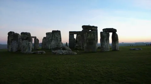
Stonehenge in the evening light, 29 December 2014, shortly after the winter solstice.
Photo: Fanfwah, CC BY-SA 4.0, via Wikimedia Commons.

The axis, the Sun and the Moon on the plan
The plan shows the stones from above, with north at the top. The pale band is the axis of 49° toward the northeast (and 229° toward the southwest), with our margin of ± 1°. The yellow and orange lines are the first light (sunrise) and last light (sunset) of the Sun at the chosen point in the year, the blue lines the extreme moonrises and moonsets in the chosen year of the lunar cycle. Below it is the horizon in the northeast and southwest at true angular scale. We do not show clock times; what matters is the direction.
The Sun moves along with the day slider.
2500 BC, solar longitude 90°: first light comes at 49.2° and last light goes at 311.2° (upper limb on the horizon of OS Terrain 50). That is 0.2° off the axis of 49°; the axis is given to the nearest degree (our margin: ± 1°).
- First light (sunrise)
- 49.2°
- horizon 0.57°, declination 23.98°
- Last light (sunset)
- 311.2°
- horizon 0.37°
- Off the axis
- 0.2°
- degrees off the axis of 49° (sunrise); the axis is given to the nearest degree, our margin is ± 1°
Stone positions: after the plan by Nash et al. 2021 (CC BY 4.0), georeferenced; accuracy about 0.3 m in the circle, about 1 m outside it. Station Stones 92 and 94 are missing; their position is derived from the rectangle. Bank, ditch and Avenue are schematic.
From the centre, eye height 1.5 m. Horizon at 49°: 0.57° (OS Terrain 50) or 0.70° (GLO-30); Ruggles assumed 0.5°, Chadburn & Ruggles give 0.60°. Solid = OS Terrain 50, dashed = GLO-30; 1° of azimuth is as wide as 1° of altitude. The Sun is drawn at true size (0.53°); the dotted disc is the Sun at first or last light, with its upper limb on the horizon.
From the centre, eye height 1.5 m. Horizon at 229°: 0.48° (OS Terrain 50) or 0.50° (GLO-30); Ruggles assumed 0.5°, Chadburn & Ruggles give 0.49°. Solid = OS Terrain 50, dashed = GLO-30; 1° of azimuth is as wide as 1° of altitude. The Sun is drawn at true size (0.53°); the dotted disc is the Sun at first or last light, with its upper limb on the horizon.
What we know and what we don’t
- Established: Stonehenge was built in phases. The bank and ditch date from about 3000–2920 BC; the sarsen circle, the horseshoe of trilithons and probably also the Station Stones from about 2620–2480 BC; the Avenue from about 2480–2280 BC (Darvill et al. 2012; dates with uncertainty).
- Measured: the main axis runs from the northeast, the direction of the rising midsummer Sun, to the southwest, the direction of the setting midwinter Sun. Ruggles (1997) gives it as 49°, to the nearest degree; he himself writes that this direction is not precisely fixed.
- Widely accepted: that the solstitial axis is intentional. Which direction weighed most is an interpretation. Darvill et al. (2012) find that the layout of the horseshoe of trilithons in particular points to midwinter; Ruggles (1997) also describes the effect of the midsummer light through the entrance, between the Heel Stone and its partner.
- Debated: the Heel Stone. A large stone hole has been found next to it. Darvill et al. (2012) read two stones there that flanked the axis; Parker Pearson thinks the Heel Stone is the stone from that hole, moved later.
- Debated: the Avenue. In the ground beneath the Avenue lie natural stripes and ridges that already lay on the solstice line. Allen et al. (2016) consider it possible that this line determined the direction of the monument; whether that was intent or coincidence remains an interpretation.
- Debated: the Station Stones and the Moon. The long side of their rectangle points roughly toward the extreme Moon positions (Newham 1966; Hawkins 1963). Atkinson (1966) calculated that so many alignments often occur by chance, and Ruggles (1997) sees no convincing evidence for many accurate alignments at Stonehenge. Whether the lunar direction is intentional, we do not know.
- Unknown: the results of the observations of the major lunar standstill of 2024–2025 (English Heritage; Ruggles, Chadburn and Silva) have not yet been published.
- Our calculation says what was geometrically possible, not what the builders intended.
Our calculation
We calculate from the centre of the stone circle (eye height 1.5 m), with the Sun from our own model (obliquity IAU 2006, Kepler orbit) and the real horizon from OS Terrain 50. First and last light is the moment when the upper limb of the Sun (the first bit of Sun that appears above the horizon at sunrise, and the last bit that disappears at sunset) is on the horizon, with refraction at 1010 mbar and 0 °C. Ruggles (1997) gives the axis as 49°, to the nearest degree (read from the plan by Cleal et al.), and writes himself that this direction is not precisely fixed; he gives no margin. We use a margin of ± 1°: that is our own choice (the rounding to the degree, ± 0.5°, plus the uncertainty of that plan). We therefore show the axis as a band from 48° to 50° (and from 228° to 230°), not as a single line.
| Moment | 2500 BC | 2026 |
|---|---|---|
| Midsummer sunrise (first light) | 49.2° | 50.3° |
| degrees off the axis of 49° | 0.2° | 1.3° |
| Midwinter sunset (last light) | 230.2° | 231.2° |
| degrees off the axis of 229° | 1.2° | 2.2° |
With GLO-30, first light falls about 0.4° further east (49.6° in 2500 BC). That is because the horizon at 49.6° is higher in GLO-30: 0.769° against 0.582° in OS Terrain 50, about 0.2° higher. Along the horizon the Sun moves about 1.9° in azimuth per degree of altitude, so 0.2° higher gives about 0.4° of shift. Last light hardly changes.
That the Sun falls further off the axis at the sunset end than at the sunrise end (see the table) is geometry, not an error: at a declination of ±24°, the sunrise direction in the northeast and the sunset direction in the southwest are not exactly opposite each other (about 1° difference). That is because at sunrise and sunset the Sun is not on the mathematical horizon: the horizon is a little higher, the air bends the light, and we use the upper limb. The axis is one straight line, so the Sun can fall closer to it in one direction than in the other. Both distances are of the same order as our margin for the axis (± 1°); they say nothing about what the builders intended.
In 4,500 years the Sun at the solstice has shifted about 1.1°: the sunrise toward the east (1.07°), the sunset toward the west (1.06°), because the obliquity of the Earth’s axis decreased from 23.98° to 23.44°.
We calculate the Moon over a full cycle of 18.6 years, with the horizontal parallax (the Moon is so close that we see it almost 1° lower than from the centre of the Earth), the upper limb and the same horizon. For the Sun we use 2026, the current year; for the Moon 2025, because the last major lunar standstill fell in 2024 and 2025. The extreme moonrise in the southeast and the extreme moonset in the northwest of the major standstill lie at 141.8° and 320.4° in 2500 BC, and at 140.5° and 319.2° in 2025. The long side of the Station Stones rectangle (about 80 m by 33 m) runs in the direction 139° to 140° (and 319° to 320°); the middle direction is 139.5° (and 319.5°). Only the moonset of 2025 (319.2°) falls within the direction of the long side itself. The other three lie outside it: the moonrise of 2025 (140.5°) at 1.0° from the middle direction, and in 2500 BC the moonset (320.4°) at 0.9° and the moonrise (141.8°) at 2.3°. Whether the long side and the Moon positions are connected, geometry cannot say. Station Stones 92 and 94 are missing; their position follows from the rectangle.
How we calculate
We choose the elevation model that best fits independent measurements, not the model that gives the nicest result.
At Maeshowe that is Copernicus GLO-30, tested against the theodolite measurements by Ruggles and MacKie: our horizon is 1.31° / 0.94° / 0.91° at 217.1° / 222.9° / 225.7°, measured is 1.3° / 1.0° / 0.9°; the largest difference is 0.06° (at 222.9°).
At Stonehenge that is OS Terrain 50, tested against the horizon profiles by Chadburn & Ruggles (2024): 0.57° against 0.60° at 49° and 0.48° against 0.49° at 229°, within 0.03°. GLO-30 lies above it (0.69° at 49°; up to 0.34° higher in the northeast section), probably because that model includes trees and buildings. That is why OS Terrain 50 is the main model here; GLO-30 is shown for comparison.
What we don’t know
- The axis comes only from Ruggles (1997): 49°, given to the nearest degree, and he himself writes that this direction is not precisely fixed. The margin of ± 1° is our own choice. We have no sharper value.
- The centre of the circle comes from one source (Chadburn & Ruggles 2024); a second source confirms it only to within 100 m. Shifting the centre by 3 m changes the first and last sunlight by at most 0.01°, and by 10 m by at most 0.02° (the extreme Moon positions by at most 0.02°).
- We calculate from the centre. The builders may have looked from a stone or from the entrance. From the entrance of the sarsen circle (16 m to the northeast) the first sunlight shifts by 0.03°, and from the Heel Stone by 0.13° (the extreme Moon positions by at most 0.16°). That is small in our model, because the horizon is low and flat. A model of 50 m does not see individual barrows, hedges or trees; they can make the horizon locally a few tenths of a degree higher, and we do not know that.
- The landscape and the trees in 2500 BC are unknown; the horizon comes from a model of today.
- Our Moon model was tested on 2025 (difference in declination smaller than 0.01°) and not on 2500 BC; for that time we calculate a truncated series without ΔT, which hardly matters over a full cycle.
- The results of the observations of the major lunar standstill of 2024–2025 (English Heritage, Ruggles, Chadburn, Silva) have not yet been published; our values for 2025 therefore have no observation to compare with.
- The positions of Station Stones 92 and 94 are derived from the rectangle; the stones themselves are missing.
Sources
- C. Ruggles, Astronomy and Stonehenge, Proceedings of the British Academy 92 (1997) 203–229. thebritishacademy.ac.uk
- T. Darvill, P. Marshall, M. Parker Pearson, G. Wainwright, Stonehenge remodelled, Antiquity 86 (2012) 1021–1040. doi.org
- M.J. Allen et al., Stonehenge’s Avenue and Bluestonehenge, Antiquity 90 (2016) 991–1008. doi.org
- A. Chadburn & C. Ruggles, Stonehenge: Sighting the Sun, Liverpool University Press for Historic England (2024); the horizon profiles from the supplementary material: web.cultural-astronomy.com/ssts-profiles. web.cultural-astronomy.com
- D.J. Nash et al., Petrological and geochemical characterisation of the sarsen stones at Stonehenge, PLoS ONE 16(8): e0254760 (2021), fig. 1; CC BY 4.0. doi.org
- Elevation data: OS Terrain 50, Contains OS data © Crown copyright and database right 2026, Open Government Licence v3.0; Copernicus GLO-30, © DLR e.V. 2010-2014 and © Airbus Defence and Space GmbH 2014-2018 provided under COPERNICUS by the European Union and ESA. osdatahub.os.uk
- Sun and Moon: N. Capitaine, P.T. Wallace, J. Chapront, Expressions for IAU 2000 precession quantities (P03), Astronomy & Astrophysics 412 (2003) 567–586; J. Meeus, Astronomical Algorithms, 2nd edition (1998), chapter 47. doi.org
- On the lunar lines, as cited by Ruggles (1997): C.A. Newham (1966), G.S. Hawkins, Nature 200 (1963), R.J.C. Atkinson, Antiquity (1966). Not read in the original.
We keep what the sources say separate from what we calculate ourselves. See also the Sky calendar for this year’s solstices.
More monuments
Also available:
Not yet available:
- Goseck (Germany)