Maeshowe and the setting winter sun
Maeshowe is a passage tomb in Orkney, Scotland, about 5,000 years old. Its passage points southwest, where the Sun sets around the winter solstice. Here you see the horizon from the entrance to scale: how the Sun disappears behind the hills and sometimes returns, what we know, and what we don’t.
Where you stand
Maeshowe lies near Stenness on Mainland, the largest island of Orkney. It is a round grass-covered mound with a single passage of about 10 m according to Historic Environment Scotland (other figures differ), leading to a chamber. The entrance faces southwest.
In the horizon view below, you stand at the entrance, looking southwest toward the hills of Hoy, the island to the southwest. What you see there comes from our own calculation with elevation data, not from a photograph.
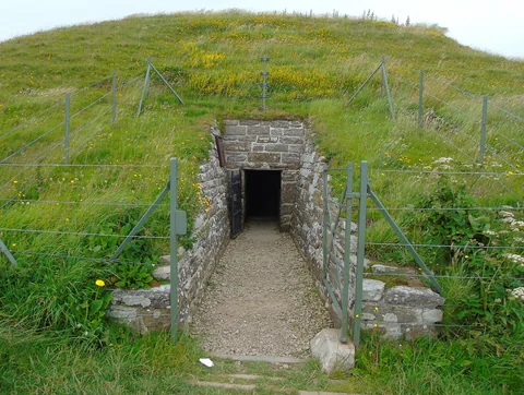
The entrance to Maeshowe, seen from outside (14 July 2022; the photographer was looking north). The passage leads into the mound; the entrance is on the southwest side.
Photo: Carroll Pierce, CC BY-SA 2.0, via Wikimedia Commons.
_-_geograph.org.uk_-_7270545.jpg)
The setting of the winter sun, to scale
The view shows the southwest horizon, 35° wide and 4.8° high, with the hills of Hoy as elevation data give them and the Sun at its true size (0.53°). Choose a year and step through the days around the solstice. The dashed lines are the axes of the passage. We do not show clock times; we show how many minutes the Sun disappears behind the hills.
3000 BC, on the day of the solstice: the Sun sets without interruption; it does not disappear behind the hills for a while.
- Declination of the Sun
- −24.02°
- at the solstice: −ε = −24.02°
- Azimuth of the last sunlight
- 216.1°
- upper limb of the Sun on the horizon of the hills
- Sun behind the hills
- none
- the Sun stays visible until it sets
What we know and what we don’t
- Accepted: the passage points to the setting of the Sun around the winter solstice; the Sun’s rays line up with the Barnhouse Stone, a standing stone southwest of the mound (Historic Environment Scotland). The Sun sets there above the hills of Hoy (Reijs, via Patat 2011; also in our calculation).
- Accepted: the light of the setting Sun shines down the passage for about three weeks before and after the winter solstice and lights the back of the chamber (Historic Environment Scotland). According to Reijs this happens for about 35 days on either side, and 5,000 years ago perhaps 40 days (quoted by Ruggles and Barclay, 2000).
- Measured: from the passage, three points of the horizon lie at azimuth 217.1°, 222.9° and 225.7° at altitudes of 1.3°, 1.0° and 0.9° (Ruggles 1979 and MacKie 1997: two independent measurements that agree to 0.1°).
- Measured: around 20 days before and after the solstice the Sun disappears behind Ward Hill, reappears 7 to 8 minutes later for a few minutes, and then sets for good: about 2 minutes according to Reijs (via Patat 2011), 3 to 4 minutes in our model.
- Disputed: whether the axis of the passage fits the solstice itself or sunsets about three weeks earlier or later. Ruggles (1999) says the latter: the axis of the inner passage, azimuth 221°, fits the Sun of about three weeks earlier or later. Older sources name the solstice itself (Ritchie 1985, Parker Pearson 1993) or a few weeks earlier and later (Burl 1981).
- Disputed: whether the alignment was precise. MacKie (1997) sees an observing instrument in Maeshowe, with two precise alignments on horizon points and a calendar of 16 months. Ruggles and Barclay (2000) see a broad cosmology and no exact calendar, and point out that the Sun reaches the back wall for dozens of days.
- Unknown: the original form of the outer passage and the entrance. They were rebuilt after the excavation of 1861, and much of what has been written about the solstice concerns the present form. Nor did we find the passage dimensions needed to calculate on which days the light reaches the back wall (the position of the bend, the width of each section). So we draw no range, only the two axes.
- Our calculation says what the horizon and the Sun do. It says nothing about what the builders intended. The age is also an estimate (about 2800 BC; no direct dating of the construction found); so we show 3000 BC and call that uncertain.
Our calculation
| Location | 58.9966° N, 3.1882° W (the centre of the mound according to Historic Environment Scotland); our observer stands at the entrance, 17 m to the southwest (estimated) |
|---|---|
| Horizon | Copernicus GLO-30 (surface model, about 30 m), azimuth 195° to 255° in steps of 0.05°, with Earth’s curvature and refraction (k = 0.13) |
| Observer | 14.0 m above sea level (the model’s height at the entrance plus 1.5 m eye height; with the height of OS Terrain 50, 16.7 m, the horizon fits the measurements worse) |
| Sun | obliquity IAU 2006 (P03), Kepler orbit with the eccentricity and perihelion of that year, refraction after Sæmundsson at 1010 mbar and 0 °C (as at Newgrange) |
| Horizon check | altitude at 217.1°, 222.9° and 225.7°: 1.31°, 0.94° and 0.91°; measured 1.3°, 1.0° and 0.9°. Ward Hill: 476.6 m in the model and 479 m on the map, at 13.75 km |
| Return check | 2026, 20 days before the solstice (declination −21.90°): gone about 7 minutes and then visible for a few minutes (3 to 4 minutes in our model); Reijs and Patat: after 7 to 8 minutes, about 2 minutes |
| What differs | the point where the left slope of Ward Hill meets the nearby ground lies at 216.7° in the model and at 217.0° to 217.1° in the measurement: a difference of 0.3° to 0.4°. A second model (OS Terrain 50) gives the same |
| Return of the Sun | in 2026 around 20 and 41 days before and after the solstice, in 3000 BC around 23 to 24 and 43 to 44 days (the larger obliquity shifts the days) |
| Axis and Sun’s path | In 3000 BC the Sun set on the solstice at about 216° (last light: the upper limb of the Sun on the horizon of the hills), on the axis of the outer section of the passage (rebuilt; its original form is unknown). The axis of the inner passage (221°) lies between the last light of 22 and that of 24 days before the solstice (219.8° and 223.4°), and about as far after it: at the Sun of about three weeks earlier or later. That is geometry of the axes and the Sun’s path; it says nothing about what the builders intended. |
We do not show clock times: the uncertainty in the Earth’s rotation (ΔT) is too large for 3000 BC. The duration in minutes does not depend on it.
How we calculate
We calculate the horizon ourselves from elevation data, as Patat (2011) describes: from the entrance we walk away in every direction and take the largest altitude angle, with Earth’s curvature and the refraction of the air. Compared with the measurements of Ruggles and MacKie it agrees to within 0.01° to 0.06°, except for the transition at 217°.
We calculate the Sun with our own model, which also holds for 3000 BC. For each day we follow the Sun in steps of a quarter of a minute and count how much of the disc clears the horizon. That tells us how long it disappears behind the hills.
That the axis of the inner passage lies between the last light of 22 and 24 days before or after the solstice agrees with what Ruggles says about sunsets ‘some three weeks earlier or later’. A second elevation model, OS Terrain 50 from the Ordnance Survey, gives almost the same horizon (differences up to 0.04° in altitude); we did not use laser elevation data (lidar).
Sources
- C. Ruggles and G. Barclay, Cosmology, calendars and society in Neolithic Orkney: a rejoinder to Euan MacKie, Antiquity 74 (2000) 62–74. doi.org
- E.W. MacKie, Maeshowe and the winter solstice: ceremonial aspects of the Orkney Grooved Ware culture, Antiquity 71 (1997) 338–359. Read via Ruggles and Barclay (2000).
- C. Ruggles, Astronomy in Prehistoric Britain and Ireland, Yale University Press (1999). The sentence on the axis of the inner passage (221°) was read as a quotation.
- F. Patat, Horizon synthesis for archaeo-astronomical purposes, Astronomische Nachrichten 332 (2011), no. 7, 743–749. doi.org
- Historic Environment Scotland, Maeshowe Chambered Cairn: history and stories, and the scheduling record SM90209. historicenvironment.scot
- J. Stuart, Notice of excavations in the chambered mound of Maes-Howe, Proceedings of the Society of Antiquaries of Scotland 5 (1864). journals.socantscot.org
- V. Reijs, measurements and 3D model of Maeshowe (1998, 2001). Read via Ruggles and Barclay (2000), Patat (2011) and the Ness of Brodgar site.
- Ness of Brodgar Trust, Maeshowe and the winter solstice (2020). nessofbrodgar.co.uk
- Elevation data: Copernicus DEM GLO-30, © DLR e.V. 2010–2014 and © Airbus Defence and Space GmbH 2014–2018, provided under COPERNICUS by the European Union and ESA. Comparison with OS Terrain 50, Ordnance Survey (Open Government Licence v3.0).
We keep what the sources say separate from what we calculate ourselves. See also the Sky Calendar for this year’s solstices.
More monuments
Also available:
- Newgrange (Ireland)
Not yet available:
- Stonehenge (England)
- Goseck (Germany)